The foundation of the ancient city of Elea Velia is due to the Focei, inhabitants of the city of Phocaea in Asia Minor, around 540 BC. The Greek cities of Asia Minor in the 6th century B.C. they were affected by the attacks of the Persians and also Focea whose inhabitants left the city and headed with their boats towards the West; they stopped in Alalia, in Corsica, where they already had their emporium, and here they turned to trade and piracy (widely practiced in ancient times) to the point of provoking the reaction of the Etruscans and Carthaginians, who were injured in their commercial interests, who defeated the Focei in the Alalia’s naval battle. The survivors with about twenty ships repaired to Reggio where a citizen of Poseidonia, interpreting a response eracolare, indicated them the site where they should have founded the city (Herodotus). The Focei settled on the promontory and in the small valley to the south that still bears the name of the ancient city. The first inhabited nucleus extended from the acropolis to the southern slopes of the city, up to the second insula, protected by defensive walls, with a still reduced thickness of 1.8 meters, which followed the ridge of the hill. A few years after its foundation, in the 5th century a.C., Velia was a fairly prosperous city, counting among its citizens the illustrious minds of Parmenides and Zeno which also gave it legislation. Its defensive system, not limited only to the city but extended to the whole territory, allowed it to successfully buffer the pressure of the Lucanians in the 4th century. B.C. in the Roman period – Republican Velia was an ally of Rome and supported her in her wars of conquest; in 88 BC became Municipium, hosted Brutus, who had a villa there and Cicero, during the period of the civil war. In the Roman-imperial period Velia was much appreciated as a holiday resort for its mild climate; it was the site of an ancient medical school (see sheet). The economy of the city, however, is beginning to suffer blows both for the further cover-up of the ports, and for the geographical exclusion from the major roads. In the Middle Ages the upper parts of the city were inhabited, better defensible and far from areas subject to swamping.
Before beginning the description of the ruins of the ancient city it is good to give a quick glance at its territory (further details in the appropriate tab). The territory that Velia controlled extended behind the city, including, as far as the orography is concerned, the mountainous area that goes from the Massif of the Monte Stella to the Gelbison, broken by the course of the river Alento; as for the coast, the Gulf of Velia was closed to the north by the promontory of Licosa and to the south by the promontory of Palinuro. the topographical situation of the area chosen by the Foceis for the foundation of the city was different in ancient times than the present one: the promontory, which was the site of the first settlement, stretched out into the sea that lapped south of the southern quarter; to the north there was another district of the city, on the northern coastal stretch they flowed into two rivers, the Alento and the Palistro, the latter which was a tributary of the Alento, you must perhaps beexploited for the construction of a river port. The city had a defensive system represented by a well-designed wall belt: it wound along the ridge of the hill to reach Castelluccio (watchtower that closed the northern fortifications) from where it descended to arrive at Porta Marina sud, from here it went up towards Porta Rosa, leaving the acropolis outside the walls, to the north of the walls, which follows the crest of the hill, another arm of them joins that goes down to Porta Marina Nord and closes, in this way, the neighborhood Northern. The promontory served as a divider to the two quarters of the city, the South and North districts, which communicate with each other via the Via di Porta Rosa.
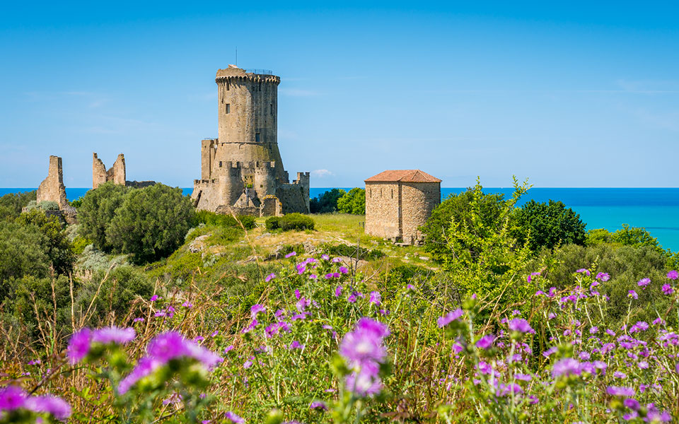
The acropolis was the site of the city’s first urban layout; the dwellings, of which only the stone plinth has remained (the riser had to have been made of raw bricks and has not been preserved), arranged on terraces, open towards the east on north-south roads, onto which more narrow streets are grafted small with east-west direction; this village is built in polygonal technique, very carefully set up (polygonal lesbio), a construction technique typical of Asia Minor. Behind the village you can see a large terracing wall that overlaps the polygonal houses, built around 480 BC. and which is part of a first arrangement of the acropolis; from this moment the village on the acropolis is no longer in operation and the urbanization of the lower parts of the city begins. The acropolis now houses sacred and public monuments of the great temple, certainly Ionic, perhaps dedicated to Athena, dating back to around 480 BC who came to obliterate the oldest sacred monuments as the findings of Ionic antefixes dating from around 530 BC could prove. and the beautiful polygonal wall with sharp edges; the medieval tower of the Angevin age (13th century) overlaps the temple.
On the other hand, in the 3rd century BC, the theater was set against the terracing wall of the temple, of which the analmma remains (bearing wall) and stretches of the steps; the remains of a rectangular building, which perhaps served to contain votive offerings (tesauròs), immediately followed it to the south. Access to the sanctuary is transformed with the construction of a monumental road that, passing through a ramp on the ancient terraces, reaches a propylon entrance to the main sanctuary. In front of the large terracing wall a stoà is implanted and another portico was built to the west of the temple. Continuing eastwards, passing near a Roman cistern, we set off towards some sacred squares bordered by the walls that enclose the city. On the first terrace you can see the remains of a U-shaped portico, bases of steles, remains of an altar; a stele inscribed with a dedication to Poseidon Asfaleiou (protector) of IV sc. BC, tells us that this terrace was sacred to that god. The route, which reaches Castelluccio, an extreme fortification of the walls, runs along the walls that have had various construction phases: from an archaic polygonal phase with raised bricks, we arrive at the arrangement of the walls that was strengthened in the 4th century. B.C. in square work with raised in baked bricks and turrets at a regular distance. We then pass over Porta Rosa that after about 400 meters is the graft of the walls that surround the northern quarter, immediately afterwards there is a large space in front of it, preceded by the remains of a temple in antis of the late Hellenistic age; the area of about 100 square meters commonly called Ara Pagana, supported by terraces and with a large altar (m. 25×7), served perhaps for religious and political public gatherings. At about 300 m. from the Pagan altar, continuing to follow the walls that incorporate numerous towers, is a mighty fortification (m. 27×10,80) called Castelluccio, an extreme defensive point where the two arms of the walls are connected those of the ridge and those that descend towards the south, which reached the sea. Following the walls, interrupted in some parts, we arrive at the well-fortified southern quarter. The mighty fortifications were built in large blocks of sandstone with ashlar work, in them opened a door, Porta Marina Sud, which breaks their course. The door system dates back to the 5th century. B.C. and has had various remakes. The southern quarter, the largest in the city, is part of the urban transformation of the first half of the 5th century. B.C. The city, as the excavations in loc. Vignale, is organized with an orthogonal system of streets and houses with the classic subdivision “by strigas”, characterized by parallel streets 4 and 40 meters wide; each insula measured 37.35 meters while the width of a housing unit was m. 15.50 and resulted from the division of the insula into two equal parts, each lot measured therefore m. 17, 50 x 16, 50.
At the end of the 4th century B.C. the southern area was perhaps affected by floods and received housing and public buildings. The monumental renewal of the urban layout of the end of the 4th century to. C. sees the lower city incorporated among the urban quarters; the new arrangement of the old southern quarter shows a diversity of orientation with respect to the urban layout of the districts of loc. Vignale. Entering from Porta Marina Sud, preceded by a wall in c.d. velina technique, we have on the left the first insula that houses various houses with rooms arranged around a courtyard equipped with watershed and well. On the right of Porta Marina Sud there is the insula II which also from the III century BC to the I BC hosted homes; in the first century B.C. the houses gave way to a complex of buildings consisting of a U-shaped cryptoporticus and a triporticus, with a colonnade on three sides and an access stairway; the triportico is of the II sec. A.D. In the complex one can recognize a caesareum, that is a building used for the cult of the Emperor. On the left, take the street of the sacred well bordered by a thermal building probably from the 2nd century. d. C. with a beautiful mosaic of black and white tiles inside; this leads to the sacred well, built in velina technique and dating back to the III century. B.C.; it collects votive offerings and was perhaps dedicated to Eros, as the letters EP engraved on the rock behind could indicate.
Going back, take the road on the left, it is the road that will lead us to Porta Rosa, called via di Porta Rosa, perhaps the ancient via del nume mentioned in a fragment of the work of Parmenides, whose pavement is in blocks of limestone cutting places. Continuing along this road on the right there is a structure completely covered internally with cocciopesto, a tank for the thermal water supply; more or less in front, on the left, there are the remains of two towers placed 25 meters from each other that belonged to the ancient walls of the city, next to the second tower there is a door that led to a street which led to the acropolis; beyond the door there are the remains of a neighborhood from the Hellenistic period. Continuing along via di Porta Rosa, on the right we see a large clearing identified, with the first excavations, as Agorà, whose plant dates back to the 5th century. to. C. more completely redone in the III century B.C.; it is however probable that this monumental complex, with shops behind it preceded by porticoes on three sides, is a clearing with fountains, fed by abundant springs. Higher up, on the left, there is a source embedded in the terracing walls and covered in ancient by a double-pitched roof that dates back to its first layout in the 6th century. B.C. On the right of via Porta Rosa you can see the remains of a thermal plant from the Hellenistic period dating back to the first decades of the III century. B.C. powered by a very rich spring, it represents one of the oldest examples of Hellenistic thermal plants of Magna Grecia; has a hypocaust system that served to keep the water temperature warm and a second praefurnium in the same compartment as the boiler; the interior decoration was a mosaic.
Resuming the steep ascent of Via Porta Rosa, suddenly, after the curve there appears the monumental arch of Porta Rosa preceded by Porta Arcaica; the plant of “Porta Arcaica” traced in the first excavations, to the VI century. B.C. according to more recent studies, it is contemporary with Porta Rosa; real door, it closed according to the southern quarter; this is perhaps the door mentioned by Parmenides, in his poem, crossed by the street of the nume, behind the archaic door is the monumental arch of Porta Rosa; preceded by isodomic terracing walls, Porta Rosa, monumental arrangement of the gorge within which this Greek arch is implanted, has a rounded arch with radial ashlars, surmounted by a discharge arch; this monument, proportioned in all its parts, is dated to the fourth century. B.C. and it is a unique work in all the Magna Graecia.
From Porta Rosa the road heads towards the northern district, still little explored, surrounded by walls that close it to the north with a door called Porta Marina Nord. This neighborhood from what emerges from some archaeological data, was abandoned around the III century. B.C. other archaeological remains are from the 1st century A.D. In Contrada Vasalia are the conspicuous remains of a III century furnace B.C. and not far from them the remains of some rooms for the decantation of the clay and the drying of the bricks; about fifty meters away the remains of a private house perhaps from the 4th century. B.C. Velia was the seat, from the 5th century. B.C. of the famous Eleatic philosophical school which, following the thought of Senofone di Colofone, gave continuity to the Ionic naturalistic philosophy with its most illustrious representatives Parmenides and Zeno.
Parmenides of Elea was also a legislator, the Corpus of his laws reflected the idea of a conservative and oligarchic state; Strabone tells that it was the “good government” of Parmenides and, later on of Zeno, to allow, to velia to resist, later, to the Lucani and to the Poseidoniati, also being inferior for territory and for number of inhabitants.
The medical school connected to the Parmenidea philosophical school played a fundamental role in Eleatic culture.